
Although I don’t write about them here, much, we have a nice selection of Bible reference books, one-volume commentaries, research tools on everything from what the church fathers and patristics said about Bible texts to how the Scriptures came together; we have a good number of things on the Dead Sea Scrolls and a few Greek and Hebrew aids. Most often, though, we sell Bible dictionaries and concordances. Yet, since the Scriptures are a Story about God’s redemptive history in time, that is, in real history, that is, in true places, which we call geography, we’d like to suggest that folks get in the habit of using Bible atlases and maps. To wit, here are a few we like. I tried to list a few different sorts, depending on your needs and budget. Let us know in the comment section below if there is one you’ve found particularly helpful.
And, we would like to ask for a drum roll for these first two. The first won a prestigious award from a gang o cartographers (I wonder where cartophraphers get together, and if they use GPS to get there? Sorry; I digress.) The second is, well, just about the best and biggest one we’ve seen, ever. Both deserve a applause. Does your church have a library where they stock this stuff, at least for Bible study leaders and Sunday school teachers? Might you pass this on to whoever stocks such a resource room? Thanks.
 The New Moody Atlas of the Bible Barry Beitzel (Moody Press) $49.99 We proudly list this one not only because it is recent, and won a “Gold Medallion” from the Christian Booksellers Association, but it also won, just recently, the “best book of maps [of any sort] published this year” by a professional association of cartographers. Beitzel has done numerous Bible maps (for the NIV Study Bible, for instance) and is quite the man. He has studied Semitics at Fuller Theological Seminary and general linguistics at the University of Pennsylvania. The association honors map-makers by giving awards to maps, guidebooks, wall maps, and various sorts of examples of their work and this New Moody Atlas won in the category of maps in a printed book. It is a comprehensive survey of important Bible locations and events and offers great looks at Bible history and geography. It is really informative, up-to-date, and very clear in tone and content. It has several good indexes (so you can find the same place as it may be shown on different maps) and lots of Bible citations. It is getting rave reviews from some of our best Bible scholars (Tremper Longman, Doug Moo, etc.) It has good articles, lots of color illustrations, and nearly 120 different clearly-done maps. Kudos.
 The ESV Bible Atlas John Currid & David Barrett (Crossway) introductory price, $49.99; soon, $55.00 This is the largest and heaviest map book we have in the store (and it further includes a big poster, and a CD-rom) and includes over 175 full-color maps! Written by a Bible scholar and an experienced cartographer, it is perhaps the best ever done. It shows in brilliantly designed pages the geographic, geological and historical information in a way that is easy to use and won’t overwhelm with technical information (as some tend to do.) Its size isn’t an indication that it is filled up with too much detail, but rather that it is truly comprehensive and very, very helpful. This is made by folks with great integrity who wanted to create a resource to go with the recent, conservative and highly regarded English Standard Version translation (some of the maps in this are from the acclaimed ESV Study Bible.) It is getting very truly great reviews. And, like the study Bible, it is very well made, so the pages lay flat and it is assured for durability. A truly wonderful book at an excellent value if you want a significant reference tool like this.
 The Essential Bible Guide: Bible Background with Maps, Charts, and Lists Menashe Har-El, Paul Wright, and Baruch Sarel (Abingdon) $24.95 This is a great, brand-new volume that was created in the Israel by Holy Land scholars there. It is much less weighty or thick than the previously mentioned one, but is loaded information, descriptions of Iron Age-era confederations and battles and tribes and mountain ranges and seas and cities and cultural customs. As you would expect there are plenty of colorful illustrations and scenic photopgraphy and such. It has 115 pages and over 60 maps. Very handsome.
The Historical Atlas of the Bible Lands Caroline Hull & Andrew Jotischky (Penguin) $20.00 This is a light-weight medium-sized paperback, nicely done on glossy paper, and a mainstream classic used in college classes and the like. It has lists of kings and historical figures, great photos and artwork reconstructions, and over 50 full color maps. There may be more text here than maps, and so much reads more like a Bible encyclopedia.
Oxford Bible Atlas fourth edition Adrian Curtis (Oxford University Press) $24.95 This latest edition of this small classic is very nicely done, drawing on contemporary, modern, critical scholarship. There are only 27 maps, though, but some are the latest “three-dimensional” computer generated ones, so it looks great and is quite helpful. There is a lot on ancient history, archeology, geography and such and a few pages that I found less useful, too.
IVP Atlas of Bible History Paul Lawrence (IVP) $45.00
This, too, is an award-winning  volume, having been award just a few years ago the best book of its kind by the CBA, earning the “Gold Medallion.” We certainly commend it as one of the very best ever done. There were a host of thoughtful scholars, Bible guys, archeologists, historians and writers who consulted to put this remarkable book together. We enjoy how it is written, how reliable it is, and the good design. It does take a narrative approach, so the writing is helpful, captivating, and draws readers in to the big picture of the Holy drama. One reviewer said it was a “visually rich work, brimming with high-quality photographs.” It has nearly 100 relief maps.
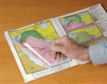 Then and Now Bible Maps (Rose) $19.97 This is a fascinating, spiral bound volume that has dozens of maps of Bible times and places, and clear plastic overlays that allow you to compare modern-day cities and countries. It includes some time lines co
mparing the Bible chronology and world history, too. The maps are basic and clear (not the award-winning and stunning cartography in the first few) but are very, very useful, since few people know the ancient-to-modern comparison of Bible lands.
Nelson’s Complete Book of Bible Maps and Charts (third edition) (Nelson) $19.99 This is less an atlas and more a big paperback collection of useful resources, lists, outlines of each section of the Bible and interesting stuff of all sorts. The maps are exceptionally clear (but quite basic; no 3D or handsome ones like in the true atlas style reference books) and there are charts galore. These are reproducible, too, so can be used for handouts or reference. There are almost 500 pages of information, and it is may be useful for putting things in their proper order, along with tables and diagrams and good introductions to each book.
20% off
order here
takes you to the secure order form page
inquire here
if you have questions or need more information
Those are some nice books, I didn’t knew there were so many good bible atlas books.
Thanks for posting.